ISRO NRSC Uttarakhand Flash Flood: 7 Key Findings from Satellite Imagery
The ISRO NRSC Uttarakhand Flash Flood disaster on August 5 shook the Himalayan region, leaving destruction in its wake. Following a cloudburst and heavy rainfall, flash floods swept through Dharali and Harsil in Uttarkashi district, destroying homes, bridges, and roads.
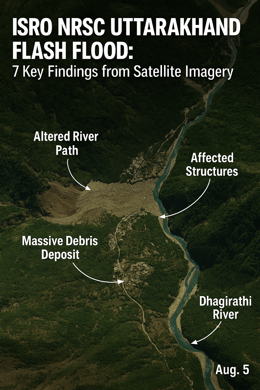
The National Remote Sensing Centre (NRSC), a vital division of the Indian Space Research Organisation (ISRO), played a pivotal role in rescue and relief efforts by deploying Cartosat-2S satellite imagery to assess the damage and guide response teams.
Satellite Insights Aiding Rescue & Relief Ops
ISRO/NRSC used Cartosat-2S data to assess the devastating Aug 5 flash flood in Dharali & Harsil, Uttarakhand.
High-res imagery reveals submerged buildings, debris spread (~20ha), & altered river paths, vital for rescue teams on… pic.twitter.com/ZK0u50NnYF
— ISRO (@isro) August 7, 2025
1. Immediate Satellite-Based Response
Within 48 hours, the ISRO NRSC Uttarakhand Flash Flood mapping team produced rapid damage assessments, comparing post-event imagery from August 7 with pre-event data from June 13, 2024. This enabled precise identification of high-damage zones.
2. Altered River Channels
The floodwaters dramatically shifted the Bhagirathi River’s course, eroding embankments and widening channels, threatening nearby communities.
3. Massive Debris Spread
A 20-hectare fan-shaped debris deposit was detected in Dharali, at the confluence of Kheer Gad and Bhagirathi River, highlighting the destructive force of the flood.
4. Severe Structural Damage
Satellite images revealed clusters of homes and buildings either destroyed or buried under mud and sediment, complicating search and rescue efforts.
5. Ongoing Rescue Operations
So far, 190 people have been rescued, with 100 still missing. The Indian Army has deployed 120 personnel for search, debris clearance, and restoration of vital connectivity.
6. ISRO’s Role in Disaster Management
The NRSC’s work shows the power of space-based disaster support, from rapid mapping to long-term recovery planning.
7. Future Preparedness for Himalayan Disasters
Experts emphasize strengthening early warning systems, improving drainage planning, and relocating highly vulnerable settlements to reduce future risks.